Cadcade Mountain are not safe now or accessible!
the urgent update on the road and trail status for those specific locations:
⚠️ Critical Closures (Do Not Go)
* Twin Falls Trailhead: CLOSED. The trail and trailhead are officially closed due to severe storm damage and flooding as of this week.
* Middle Fork Snoqualmie: HIGH RISK / AVOID. The Middle Fork Road is prone to flooding and washouts. Recent reports indicate the river access was flooded near Big River Bridge, and the area is currently unsafe.
* Highway 2 (Wallace Falls): Major Closures. US Highway 2 has experienced washouts and is closed between Skykomish and Leavenworth. While Gold Bar (where Wallace Falls is) is technically west of the closure, traveling on Hwy 2 is highly discouraged right now due to emergency repair work and changing conditions.
Current Safer Options
Given the widespread river flooding in the foothills, the “safe” list has narrowed significantly to urban parks away from major river valleys.
* Discovery Park (Seattle): This remains your safest bet. It is on a bluff away from river flood zones and major highway closures.
* Coal Creek Falls / Cougar Mountain (Newcastle): This area is generally safer as it is not in a major river valley, but check King County Road Alerts for local street closures before driving, as smaller culverts can overflow.
Where to Check Before You Drive
Since flood waters can rise and recede quickly, you must check these two real-time sources immediately before leaving:
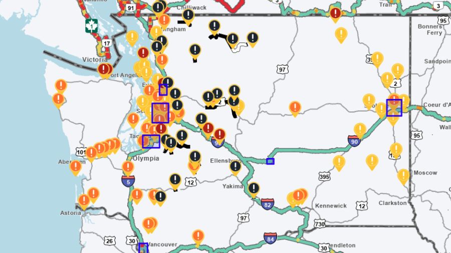
* WSDOT Real-Time Map: Check for “Red” closure icons on I-90 and Hwy 2.
* King County Flood Warning Center: Look for “Phase 3” or “Phase 4” alerts for the Snoqualmie and Issaquah rivers, which indicate water over roadways.
Recommendation: Stick to Discovery Park or other paved urban walks (like Green Lake or Seward Park) for the next few days until the flood waters recede and damage assessments are complete. The mountains are currently very hazardous.